Kentucky in the News: Kynect Enrollment
On April 22nd, Governor Steve Beshear announced that nearly 1 in 10 Kentuckians (413,410) had enrolled in Kynect (Kentucky’s state-based health benefit exchange). Enrollment took place during the health exchange’s first open period, which ended on March 31. Seventy-five percent of the enrollees were previously uninsured. In response to the statistics released regarding Kynect, Beshear stated “From the beginning, I knew that Kynect would change the course of Kentucky’s history by helping hundreds of thousands of Kentucky families, and I’ve never wavered in my support.”
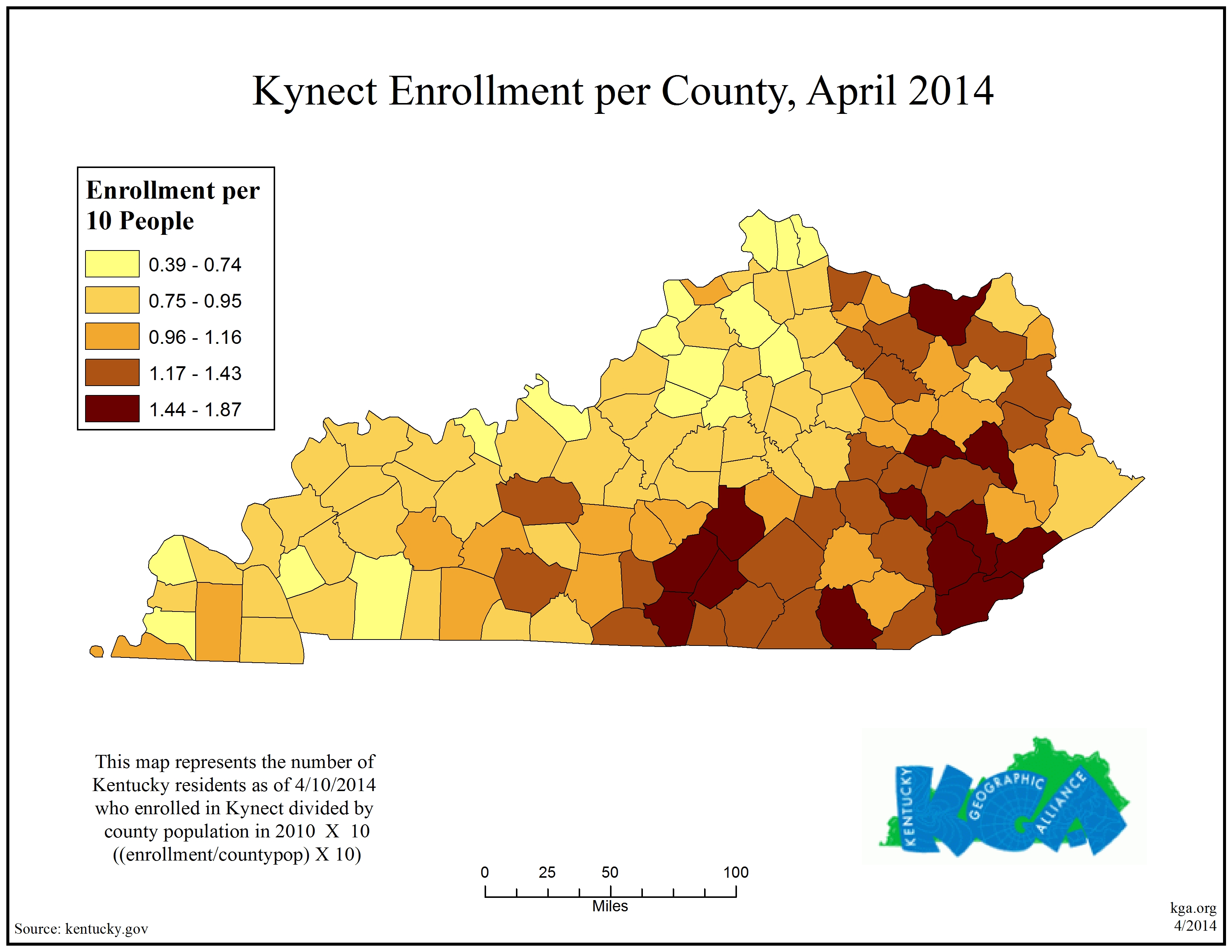
Geographic issues like socioeconomics, environmental variability, and infrastructure development can be used to explain some of the patterns displayed in the map above. What other factors do you believe play a role in this enrollment pattern? The Kentucky Geographic Alliance is interested in your constructive opinion and has created a blog for your comments.
The next open enrollment period for Kynect begins November 15. After the success of the first open enrollment, Governor Beshear expects that Kynect numbers will continue to grow as more Kentuckians become aware of the program.
Kentucky in the News: Energy Resources
Coal is a major resource in Kentucky and has been used for over 250 years. Coal mining production (see map above) has decreased in parts of both the eastern and western coal fields of Kentucky over the past year. Of the counties that decreased, Harlan County saw the largest change in tonnage produced, a decrease of 2,443,634 tons, while Elliot County saw the largest percentage increase of 1,837% from 2012 (Kentucky Coal Facts). This geographic issue highlights economic, historic, political, environmental, and cultural variability over space and time.

Recently, the central Appalachian coal industry has faced an economic downturn that has left many Kentuckians unemployed. In December 2013, the Shaping Our Appalachia Region (SOAR) summit in Pikeville focused on how to move forward during these hard times. Most recently, the Kentucky House Appropriations and Revenue Committee gave initial approval to provide economic tax incentives that reward job creation and investment.
Kentucky is in a state of transition with regards to energy. Coal is still an important resource for Kentucky and will be for years to come, but other energy sources are becoming more viable. Natural gas as an energy source is currently booming in Eastern Kentucky. A hydroelectric plant on the Ohio River in Bracken County is being installed by the city of Hamilton, Ohio. Toyota is making plans to use landfill gas to power its manufacturing plant. A more controversial Biomass power plant in Hazard, Kentucky, illustrates how Kentucky policymakers need to address new energy sources as we build a more sustainable environment.
Kentucky in the News: Corvette Collapse
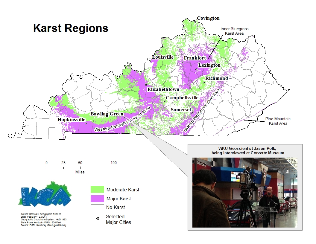
On February 12, at the National Corvette Museum located in Bowling Green, KY, a sinkhole caused the collapse of the floor inside the museum’s Skydome. No one was injured in the incident that occurred in the early morning hours, but eight corvettes were damaged as they fell into the sinkhole.
Geography is the study of the physical earth, the distribution of life and resources, and how they all interact with each other. This sinkhole event provides a textbook example of the interaction of Kentuckians with their environment. Geoscientists in WKU’s Department of Geography and Geology study events like this in order to help influence public policy and to understand how we can better interact with and manage our environment.
So what on earth happened here? The karst regions (caves) of Kentucky, outlined in the map above, show where limestone occurs at the surface of the earth. In these areas, water quickly moves underground instead of flowing along the surface as a creek or river. This year’s wet winter has affected the karst landscape in ways that might accelerate sinkhole creation. Those familiar with the geography of much of Kentucky including the Bowling Green area, shouldn’t be overly surprised by such an occurrence. This is because the geography of the area can be described as karstic. In fact, the area stretching in an arc from Hopkinsville to Bowling Green and back north to Elizabethtown lies in a major karst region known as the Western Pennyroyal.
So what is karst and why is it important? Our regional landscape is described as karst as it is characterized by caves, sinkholes, springs, and rolling hills. Mammoth Cave, the longest cave system in the world, is located in Edmonson County and is part of this regional karst landscape. Not only does karst come with the risk of creating hazardous sinkholes, such as this one at the Corvette Museum, but it can also have serious impacts on water movement and drainage. Karst has been linked to some flood prone areas.
Karst is not just located in south-central Kentucky. Other notable major karst areas exist near Somerset (Eastern Pennyroyal) and in and around Lexington/Fayette County (Inner Bluegrass). Indeed, moderate karst areas cover much of western and central Kentucky.
Understanding how we interact with our environment is what geographers do. Scott Dobler, a co-coordinator of the Kentucky Geographic Alliance, will be traveling to Washington, DC, in a few weeks to talk to legislators about geography. Currently, every core academic subject but geography has federal funding. Many challenges that we face today, like globalization (loss of Kentucky jobs to overseas industries), migration at the national level, (Kentuckians moving to other states to find jobs), and environmental change at the local level (sinkhole collapses), have impacts on Kentuckians. Help Scott Dobler support the Teaching Geography Is Fundamental Act by sending a letter to your congressman. It is easier than you think. If you are interested, visit the Speak Up For Geography website.
Please feel free to discuss in the comments below.
Related Links: Louisville Courier-Journal – Bowling Green Daily News – Kentucky Geologic Survey
KY in the News: Shaping Our Appalachia Region (SOAR)

County Economic Status in Appalachia, FY 2014 ARC.gov
On Monday, December 9th, Governor Steve Beshear and Representative Hal Rogers spearheaded a summit in Pikeville, Kentucky, called Shaping Our Appalachia Region (SOAR). The purpose of the conference was to discuss Eastern Kentucky’s economic future. The economic downturn in the region is commonly linked to the recent loss of jobs in the coal industry, but the issue has a longer history. President Lyndon B. Johnson (US president from 1963-1969) visited Martin County, KY, and declared a “war on poverty.” As this interactive map indicates, poverty was widespread across the entire southeast in the 1960s. While poverty has significantly decreased in many areas, including the Appalachian region, poverty still remains a major issue for this region in eastern Kentucky.
Geography plays a large role in this issue in regards to culture, economics, health, topography (any many other linkages). One of many proposals mentioned at the summit was the expansion of infrastructure (projects like the continued development of roads and high-speed internet).
You can link the summit to basic geo-literacy skills that have been developed to help our students with critical thinking skills. Geo-literacy is about understanding the interaction, the interconnectedness, and the implications that different people in diverse locations have on each other and how this understanding can be used in preparation for decision making. Understanding the interaction of natural resources, economics, and culture in eastern Kentucky is the first step for analysis. You can use the five themes of geography for this step. Once you have selected a topic for analysis, you can see the interconnections it has with other places in the world. A great example in the summit was presented by a representative from the state of Minnesota. He addressed the crowd about how Minnesota overcame the downturn in its iron-ore production in the northeastern region. Understanding the implications of many of the summit proposals will be key to easing the economic challenges in our Appalachia. One of many proposals that has received recent attention has been the creations of a tourism center similar to Gatlinburg, TN.
Undoubtedly, understanding the economics, culture, and the natural environment of the area will play a key role in developing a sustainable solution to the economic challenges we face in our Appalachia and other regions in the state. Linking the concepts of geo-literacy will provide an additional set of skills for other challenges that we will face in our future. You can see additional coverage on the KET and WKYT websites.
Welcome to the KGA Blog
Welcome to this new blog hosted by the Kentucky Geographic Alliance (KGA). The KGA, under the umbrella of the National Geographic Society, was established in 1987 as a partnership of K-12 teachers and academic geographers dedicated to improving the geographic literacy of Kentucky school children. The Alliance provides educators with professional development, networking, model programs, and teaching materials. It promotes public awareness of the importance of geographic literacy and skills. Part of National Geographic’s nationwide network of state geographic alliances, KGA’s programs teach students to care for the planet, its resources, and all of its inhabitants and prepare them to succeed as citizens in an increasingly global society. To learn more about the Kentucky Geographic Alliance, visit our website.
This blog will serve to help us succeed in our mission which is: “The Kentucky Geographic Alliance is an organizing force in preparing teachers and students to meet the challenging geographic knowledge and skills needed to work and live productively in today’s society.” The blog will do so by being an area in which geographic content can be posted and made available to geography educators. Furthermore we hope that the blog will serve as a location of interaction among geographic educators on the content posted. Thus, commenting on the geographic content posted is highly encouraged and is certainly welcome.

Recent Comments